Tuesday, August 9, 2022

Cross Country Adventure 2022 (day 23)

 Camping du Parc national de Plaisance, Plaisance, Quebec, Canada

8 August 2022


Plaisance lily pad.

Marc-  We packed up the camper and were on the road by 09:00 this morning despite the rain.  In fact it rained on and off (mostly on) all day.  The first leg of the trip was once again traveling on the Trans-Canada Highway (Route 17) through forested areas of Ontario.  We had a pleasant surprise when we stopped for diesel fuel on a First Nations Reservation and only paid $ 5.09 (US)/gallon. The usual price here in Canada seems to be $ 6.40/gallon (US).  I had originally thought that we would drive through Ottawa and cross the Ottawa River on the way to the Campground in Quebec.  Google routing kept sending me by way of parkways where no trucks are allowed (I feared for my camper trailer’s high vertical clearance).  I found a truck route on line routing tool that kept me away from downtown.  We chose the truck route that was scenic in that it crossed three hydro electric dams while crossing between islands in the Ottawa River.  


Ottawa River crossing - no traffic on the dams.

Ottawa River

Sue did most of the driving in the heavy rain - ouch.  We took our exit from Quebec autoroute 50 only to find that the road to the campground was closed.  Fortunately a well marked detour brought us around to the campground.  We were not completely deterred by the rain since we made a run for some food in the village of Plaisance (and were happy to find a farmer’s stand with corn, tomatoes and strawberries) and then hiked on the Zigzag Trail.


Hiking in the rain to the zigzag trail.


Campsite leaves.

Campsite view of flowering meadow.


Sunday, August 7, 2022

Cross Country Adventure 2022 (day 22)

 Sturgeon Falls KOA Campground, Sturgeon Falls, Ontario, Canada


7 August 2022


Retired North Bay Ferry


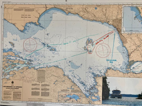
Marc-  Today we visited locally.  We started off by going to the city of North Bay nearby.  North Bay has a long public waterfront with walkway on Lake Nippising.  There is a large pier, marina, and several sandy beaches and many flower gardens.  There is also a large playground and a carousel.  The old passenger ferry, Chief Commanda, has been permanently docked as a floating bar / restaurant.  The new high speed catamaran ferry, Chief Commanda II, is tied up at the end of the City Pier.  The park also has a stage and large grassy area (this morning there was a well attended yoga session taking place).

Current ferry routes marked on the Lake chart and current ferry.

Lake Nipissing is connected to Lake Huron by the French River however a canal and locks were never made to allow ship navigation despite the above article in 1900 extolling the advantages of such a waterway.

Public yoga in the park.

Beachplum roses.

Balloon flowers.

Fried dough in the shape of a beaver's tail (very popular).

North Bay Marina


Heavy rain began to fall so we opted for an early lunch. We followed the advice of local friends Eryn and Mike and went to Average Joe’s Restaurant on Trout Lake.  The City of North Bay sits between the two lakes.  The food was good, and then we went to the Green Store nearby for ice cream and shopping.  Planes land nearby.


Planes that land on water make a lot of sense here in a land of many lakes and few roads.


On the way out of town we drove by a local tourist attraction created by a self-proclaimed artist in residence. 


Before returning to the campground we stopped to see the Sturgeon River House, a Museum of the fur trade era and early French settlers.  It is on the site of the Hudson’s Bay Company fur trading Post.  Unfortunately the Museum was closed so we toured the grounds.


Former Hudson's Bay Company Trading Post.


Saturday, August 6, 2022

Cross Country Adventure 2022 (day 21)

 Sturgeon Falls KOA Campground, Sturgeon Falls, Ontario, Canada


6 August 2022


Border Crossing at Sault Ste. Marie


Marc-  We had a 7 hour drive today from Michigan to Ontario.  The most excitement came early when we crossed over the waterway connecting Lake Superior to Lake Huron on the International Bridge at Sault St. Marie.  Beneath the bridge lies the rapids of the St. Mary’s River (21 foot drop in elevation), the Sault Ste. Marie Canal which consists of the 19th Century Canadian Locks used primarily for pleasure craft today.  The Sault Locks are on the US side of the passage and consist of giant locks, operated by the US Army Corps of Engineers, capable of passage by ships bound for Duluth or the Atlantic Ocean.  Over 10,000 ships pass through these locks annually.  The main industry can be seen North of the bridge:  the sprawling Algoma Steel Mills.


Most of the journey involved passing through woodland and a few small towns. Sue and I switch off driving every two hours or so. Our campground was easy to find and nice.  The waterfalls at Sturgeon Falls have been diverted to a hydroelectric dam.  The river is navigable above and below the dam.


International Bridge over the St. Mary's River

View of the Canadian Locks below the bridge.

Our KOA campground has its own small boat marina for those campers towing boats.


We stopped for DQ ice cream and noted the bilingual message.  The translation is a bit off.  The english should read "The Taste of Happiness".


Friday, August 5, 2022

Cross Country Adventure 2022 (day 20)

Munising / Pictured Rocks Campground, Wetmore, Michigan

5 August 2022

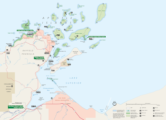
Apostle Islands National Lakeshore Visitor's Center

National Park map.

Marc- We left Minnesota early this morning and passed the Duluth bridges before rush hour.  The view from the Interstate 35 Bridge over the St. Louis River was very impressive.  The bridge has a clearance of 120 feet to allow seaway ships to pass beneath it.  At the top of the bridge we could see the entire Duluth waterfront, ships and office buildings, as well as the Western end of Lake Superior.  Duluth is the largest inland seaport in the United States thanks to the St. Lawrence Seaway.  

The highlight of the trip today was visiting the Apostle Islands National Lakeshore in and around Bayfield, Wisconsin.  The pink sand and the red rocks are nice and even the water was warm enough for swimming.  Most of the journey involved passing through forested areas with some glimpses of Lake Superior Beaches in both Wisconsin and Michigan.  We have a nice campsite in a heavily wooded area.

Pink sand beach at Little Sand Bay.

1920's vintage commercial herring fishing boat.


Local lighthouse lens.

Bayfield, Wisconsin Park Headquarters and Visitor's Center.

Various ferries servicing the Apostle Islands.

US Army Corps of Engineers workboat.

Bayfield has many beautiful flower gardens.


Thursday, August 4, 2022

Cross Country Adventure 2022 (day 19)

 Cloquet / Duluth KOA Campground, Cloquet, Minnesota


4 August 2022

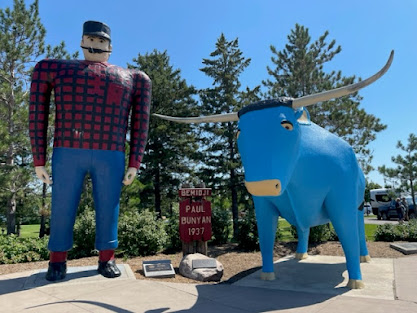
Paul Bunyan and his blue ox - the legendary lumberjack

The Mississippi River passes through here.


Marc-  Today was an 8 hour travel day.  We try to avoid this length but there were no campgrounds within a more reasonable timeframe.  The campground is in a quiet semi rural suburb of Duluth.  The scenery along Route 2 was farmland, farmland, and then forest.  We did see a few small lakes and crossed the Mississippi River twice (not a large river this far North).  The farms were cultivating wheat, corn, soybeans, canola, sunflower and flax.  The blue color of the flax fields is really cool.  Route 2 became a divided highway for 75% of the journey.  We did see some cattle (black Angus).  There was little traffic.  Once we passed the Paul Bunyan Statue in Bemidji, MN, we came upon forests and log hauling trucks.  None of the forests that we could see from the road had any large trees.  In the Duluth area we saw three large paper mills still operating.  The Sappi Mill produces high quality graphic papers.  There are also the Newpage and Georgia-Pacific mills.


No wildlife to report except one fox seen crossing Route 2.


Soybeans

Corn

Sunflowers

Black Angus cattle

Flax

Wheat


Wednesday, August 3, 2022

Cross Country Adventure 2022 (day 18)

 Roughrider Campground, Minot, North Dakota

3 August 2022

Theodore Roosevelt (the Roughrider) is very popular in North Dakota.

Our Campground.

Marc-  We left Glasgow at 09:00 headed East on Route 2 once again.  Nothing of note in the remaining part of Montana except for several oil wells in farmland.  Once we were in North Dakota the oil wells became a constant part of the landscape for the first 200 miles (this was in rolling hills of wheat and some cattle ranch areas).  This changed again as we approached Minot where trees became the norm as well as smaller farms with fields of corn, flax and canola.  The Roughrider campground was easy to find and located on the edge of Minot.  Later we explored downtown first for groceries and second for some exercise in the city parks.  Unfortunately we did not visit the Theodore Roosevelt National Park where nature is undisturbed.

North Dakota oil wells like these are everywhere.

This appears to be an oil drilling device.


Canola field.

Minot Roosevelt Park

Western style planters.