Monday, February 28, 2022

A rainy day at Blythe Island...

 28 February 2022


Blythe Island Regional Park Campground, Blythe Island, Georgia


Marc-  I started the day off with a run around the campground in light drizzle.  It was quiet with rabbits aplenty and a few Canadian geese out and about.   Sue and I later enjoyed doing the New York Times crossword puzzle on Zoom with Brian.


Our adventure for the day was visiting the Fort Frederica National Monument on St. Simons Island.  This was a nice visit despite the cool weather due to an excellent National Park Ranger who led our tour of the remnants of the Town of Frederica as well as Fort Frederica.  Ranger Sara led us past towering live oaks draped in Spanish moss to the Town Fortifications, then the streets laid out in a grid, and finally to the fort itself.  Only the foundations remain of the many houses that were once here.  Ranger Sara would stop in front of  a foundation and then show us an augmented reality version of the house that once existed here in the early 18th century.  This was a military town built in the English tradition, built to protect the Colony of Georgia from Spanish Florida.  It worked, as the British forces warded off the Spanish who tried to expel them.  The British forces attempted to dislodge the Spanish based at St. Augustine to the south without success.  


Rabbits of Blythe Island

Visiting Canadian geese

Views of the Schooner Lynx

The Lynx docked at St. Simons 

The Lynx is a topsail schooner used as a privateer and originally built in 1812 in Baltimore to defend the fledgling United States. 


It is Spring here.

The heaviest Spanish Moss on this live oak.

A Seville orange tree planted for shade and its aromatic nature in Colonial Frederica.

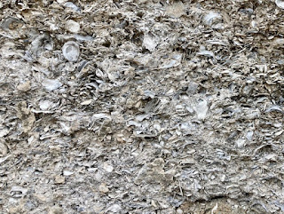
Tabby wall section of Fort Frederica. Tabby is a type of concrete used in colonial times and made by burning oyster shells to create lime, then mixing it with water, sand, ash and broken oyster shells. It was used extensively for foundations and fortress walls.
  
View from the Fort.

Christ Church (Episcopal) originally built in 1736.


Sunday, February 27, 2022

Back to St. Simons Island...

 27 February 2022


Blythe Island Regional Park Campground, Blythe Island, Georgia


Marc-  Today we returned to St. Simons Island to continue our exploration.  Some of the highlights included climbing the Lighthouse, visiting the World War II Museum in an old Coast Guard base, going to the Coast Guard Beach, visiting the shops in the Village, and playing miniature golf at the Public Library.


St. Simons Lighthouse

View from the Lighthouse

Nearby Brunswick is a major car carrier port.

The downtown beach at high tide. 

The former St. Simons Coast Guard Base. 

(At the old Coast Guard Base)

Sago palm

Coast Guard Beach in the fog.

Liberty Ships were cargo ships built in Brunswick to support the war effort in World War II.
My father was in the US Merchant Marine and served aboard many of these ships during the war.

Many women welders worked in the Brunswick Shipyard.


Scale model of a Liberty Ship.


A live oak in town getting a little extra support.  Live oaks were harvested here on St. Simons Island to construct the USS Constitution in 1797.  Many trees remain all over the island.

Chinese Holly

Indian Hawthorn

There is a new bird at the Campground.


Saturday, February 26, 2022

North to the Golden Isles of Georgia…


26 February 2022


Blythe Island Regional Park Campground, Blythe Island, Georgia


Marc- Today we left Florida as Sue drove our rig off the barrier islands to Route 95 to Georgia.  We saw two wild boars (pigs) feeding on grass alongside Route 95.  We met wild rabbits (very friendly) on arrival to the campground at Blythe Island.  This park is open year round and the campers must be feeding them.  The campsites are nestled in tall pine trees near two man made ponds and along the shore of the South Cumberland River. Facilities include a marina, swimming beach as well as hiking and biking trails.  

We had a little time to explore, and began by driving over to St. Simons Island.  We passed a huge Georgia Pacific Pulp and Paper operation in nearby Brunswick and a large marina near the downtown.  The highlight was St. Simons Village with its imposing lighthouse.   Sue and I walked around the town pier, shops, restaurants and parks and were impressed by how alive and well everything was.  Large live oaks were everywhere.  There is a lot of public space here and even the library is situated on the waterfront.   

A final drive out of North Beach Campground.

Tall trees at Blythe Island Regional Park Campground


Welcoming bunny at our campsite.


St. Simons Island Light

Giant cedar on St. Simons Island


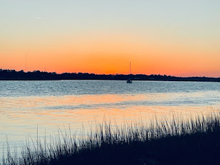
Blythe Island sunset over the South Brunswick River


Friday, February 25, 2022

Last days in St. Augustine...

   21 - 22  February 2022 

North Beach Campground Resort, St. Augustine, FL 

Marc-  We have continued to explore the St Augustine area.  A favorite stop was the Washington Oaks State Park just South of St. Augustine in Palm Coast.  This park sits on the barrier island next to Marineland.  It includes the tallest live oaks, hickory and magnolias we have seen in the South.  In addition is the undergrowth of tropical plants including various palms.  We traversed several walking trails and several bike paths.  The park crosses the island from the Atlantic beach to the Intracoastal Waterway.  The crown jewel is the formal gardens created by the Young family who donated this land to the State of Florida.  The flowers include camellias, roses, azaleas and even several monkey trees.


_______________

Back at North Beach Campground

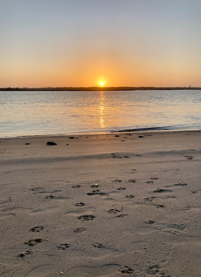
A very dog friendly ICW beach.


Strong current at the fish docks.

Our friend Wayne Lambert joined us for dinner.

_____________________

We also attended America's Boating Club annual meeting at the nearby PGA Sawgrass Resort.  There was much discussion at the meetings about staying up with the new technologies and resources for navigation.  I met with the US Army Corps of Engineers representative and discussed their work making available surveys for electronic navigational charts.  I also met with the Cooperative Charting Committee on this development.  Below is an example of electronic charts and the value of superimposed surveys on navigation.  


Notice the shallow sandbar area shown in light green, yellow and orange, and how the navigation channel takes you into it.  The survey also shows a natural deep water channel around this area.


Here we have the St. Augustine Inlet (note the lack of aides to navigation)


This is a passage through Sisters Creek in the ICW showing a narrow passage with precision.

We used electronic software by Aqua Map that had integrated the USACE surveys seen above during our 9 month journey form Vermont to the Florida Keys and back and never ran aground.